You can reach open mountain views and wild pony country without committing to an all-day hike. That’s the sweet spot for a first visit to Grayson Highlands State Park. Start at Massie Gap, take the Rhododendron Trail toward the high country, and decide how far to continue once you see the weather and trail conditions.
Hiking in Grayson Highlands gets more demanding when you push onto rocky ridges or toward Mount Rogers. A little route planning lets you enjoy the scenery without turning a good day into a long, cold walk back to the car.
Key Takeaways
- For a chance to see wild ponies, start at Massie Gap and follow the Rhododendron Trail toward the Appalachian Trail.
- Choose Twin Pinnacles for a shorter hike with big views, without needing to pursue a pony sighting.
- Mount Rogers is a full-day outing from the park. Its wooded summit is less scenic than the open ridges along the way.
- Keep your distance from ponies, and never feed or pet them.
- Check the forecast, park alerts, and campground status before driving up. Conditions can change quickly at this elevation.
Start With the Right Parking Area and Map
Use Massie Gap for pony country
Massie Gap is the most useful parking area if your goal is the Rhododendron Trail, Wilburn Ridge, or Mount Rogers. It’s inside Grayson Highlands State Park near Mouth of Wilson, Virginia. Arrive early on pleasant weekends, when the main hiking area is likely to be busy.
There is a park parking fee, and overnight backpacker parking has separate rules and charges. Check the official Virginia state parks listing and official Grayson Highlands park page before you leave for current fees, alerts, and facility information. If you plan to use the visitor center, verify its current hours and availability. Don’t assume an open gate means every trail or amenity is available.
Know where the park map stops
The park’s routes connect with the Appalachian Trail and paths in the Mount Rogers National Recreation Area. That makes it easy to walk beyond the area covered by a simple park map without noticing.
Download the official trail guide before arriving, and carry a paper map for a longer hike. Cell service may be unreliable. At each junction, check whether signs point to hiking trails or horse trails. Note where your return route leaves the Appalachian Trail for Massie Gap. The open terrain looks wonderfully straightforward until fog rolls across it.
Pick an Easy Grayson Highlands Hiking Trail
You don’t need to chase Mount Rogers to have a memorable day. These shorter options give beginners a better chance to enjoy the scenery at their own pace.
Rhododendron Trail: the short route toward the ponies
The park lists the Rhododendron Trail at 0.3 mile. From Massie Gap, it’s the natural way to head toward pony habitat and the Appalachian Trail. Keep in mind that the named park trail’s mileage isn’t the total distance you’ll walk from your parking spot to a viewpoint and back.
The path climbs into exposed terrain, where rocks, mud, and weather can make the short route feel more demanding. Check the map to distinguish designated hiking trails from horse trails, and take care on the rocky footing. This isn’t technical rock scrambling.
For a lighter outing, walk toward the ridge, enjoy whatever views and wildlife you find, then turn around before the footing stops feeling fun.
Twin Pinnacles Trail: views without a long ridge trek
The park lists Twin Pinnacles Trail at 1.3 miles, making it an approachable hike with scenic vistas. Little Pinnacle and Big Pinnacle offer overlooks without making Mount Rogers the day’s project.
Expect uneven, rocky footing and take your time near the overlooks, especially after rain. Pause at Big Pinnacle for the view, but don’t count on seeing ponies along this route. Choose it for the overlooks, then explore another area if you still have time and energy.
Decide How Far to Follow the Open Ridges
Wilburn Ridge is the scenic payoff
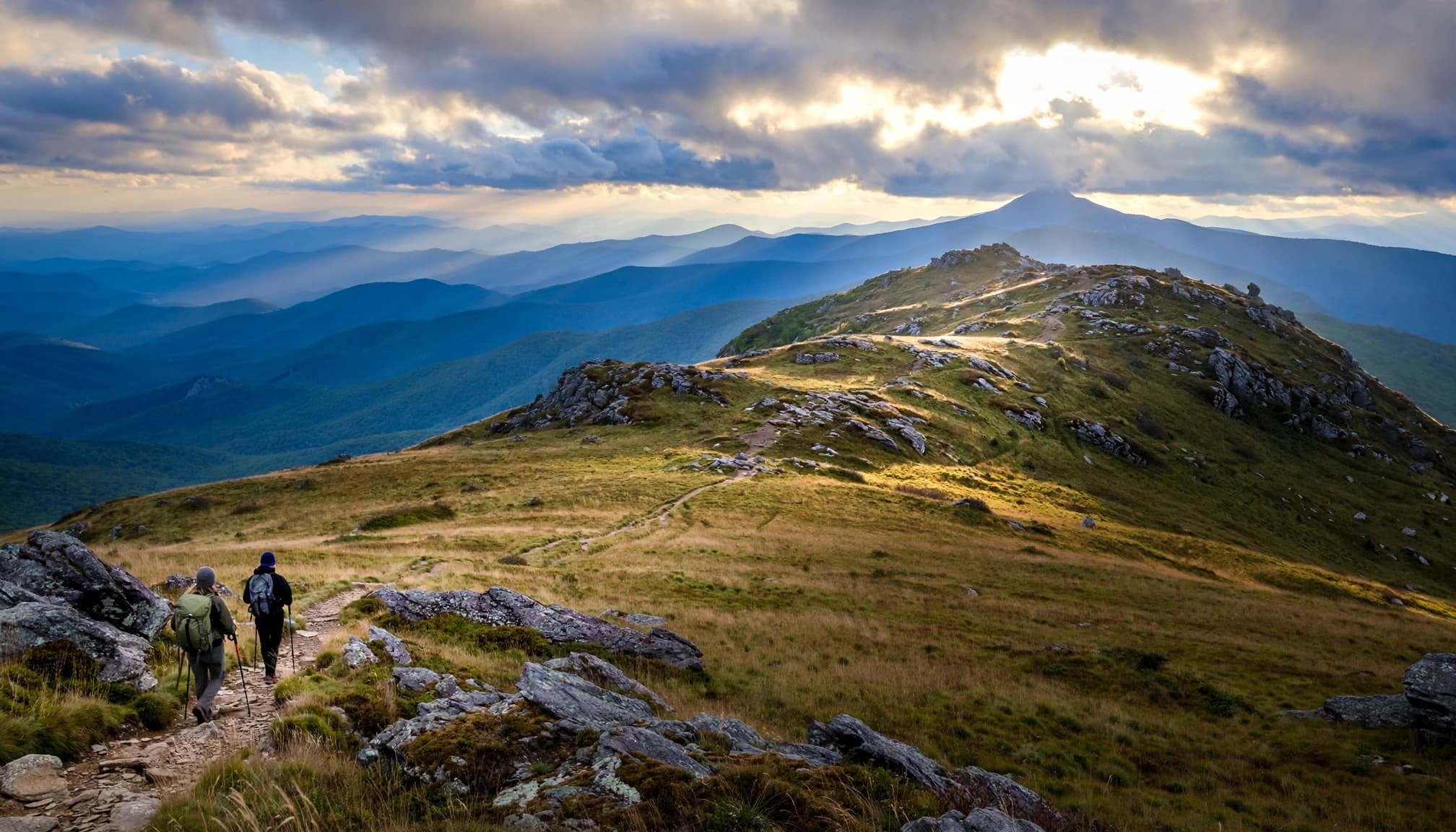
Once you connect with the Appalachian Trail, the route toward Wilburn Ridge trades a straightforward path for rockier, more exposed hiking. In rougher spots, the footing can call for rock scrambling, though not every hiker will need to do it. The reward is the high elevation views people picture at Grayson Highlands: grassy slopes, scattered boulders, and blue mountain layers.
You can make this an out-and-back rather than forcing a particular loop. Turn around when the rocks feel too slick, clouds begin closing in, or you’ve had enough climbing. If you ask me, time spent enjoying a clear ridge beats extra mileage in a hurry.
Mount Rogers takes a full-day commitment
Mount Rogers is Virginia’s highest point, but its summit is wooded. If you’re hiking mainly for wide-open views, enjoy the exposed stretches on the way and treat the summit as an optional goal.
Mileage varies with the exact starting point and route. The Virginia Department of Wildlife Resources route description gives 4.2 miles one way for a route from Massie Gap to the summit. Other route descriptions use different junctions and report longer distances. Plan for a substantial round trip to Mount Rogers, carry enough food and water for a full day, and leave time to return in daylight.
Where to See the Wild Ponies
Look around the trail, not for a guaranteed spot
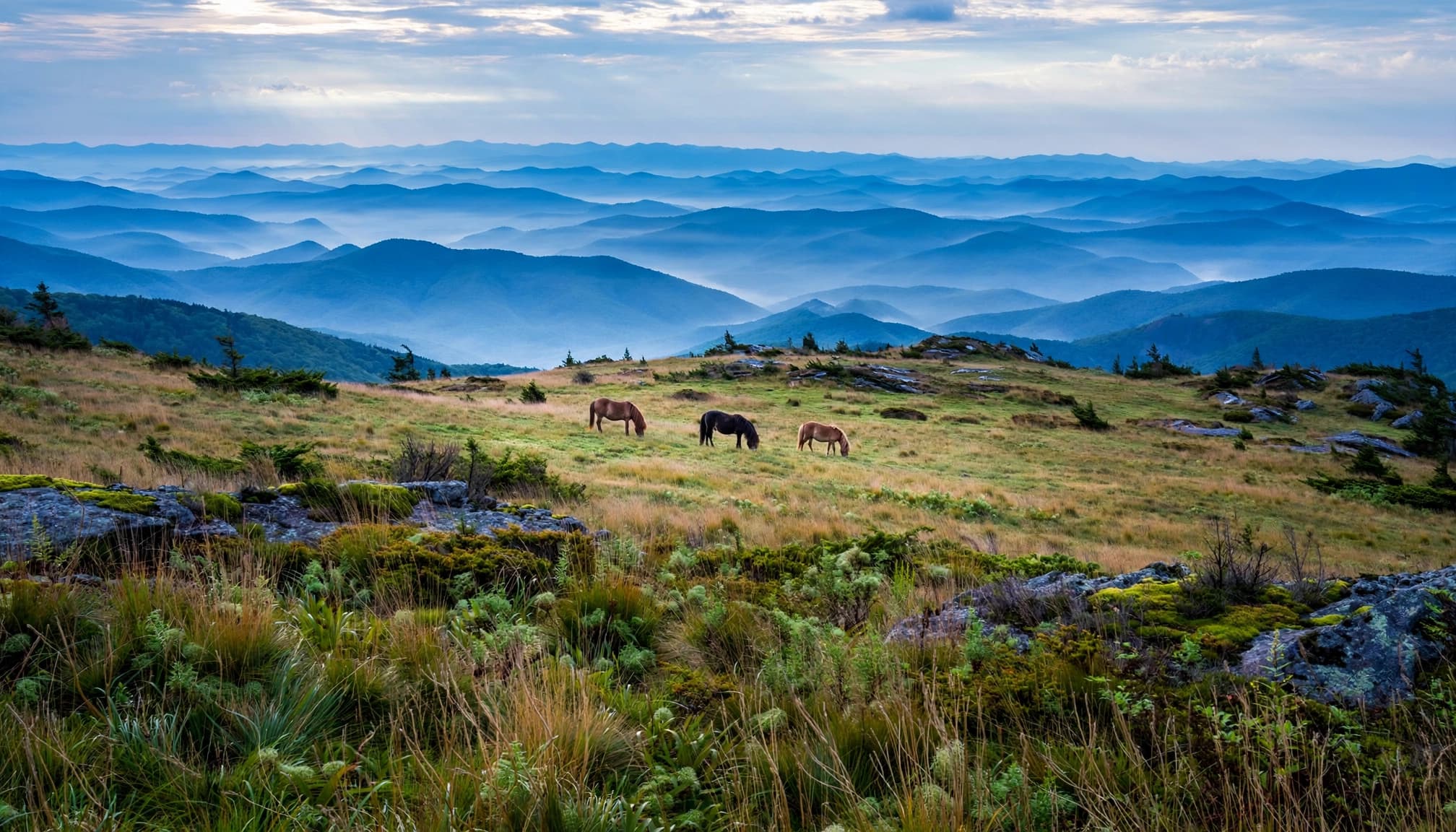
Ponies roam the highlands, often in the country reached from Massie Gap toward the Appalachian Trail and Wilburn Ridge. These wild ponies are free-roaming animals, so no trailhead or time of day guarantees a sighting.
Walk slowly, scan the slopes, and give yourself time to enjoy the ridge even if the ponies are elsewhere. To leave no trace, stay on marked routes, don’t crowd them for photos, and pack out all waste.
Give them space
The park tells visitors not to approach, feed, or pet the ponies. They can bite or kick, and human food can make them seriously ill. Keep children close and control your dog. If a pony approaches you, calmly move away rather than offering food or reaching out.
That rule applies even when a pony seems comfortable around hikers. The best encounter is one where the animal keeps grazing and you get to watch from a respectful distance.
Time Your Visit for Blooms, Color, and Safer Footing
Spring and fall have different rewards
Rhododendron blooms can be a highlight in late spring and early summer, but peak timing varies with weather and elevation. If flowers are the main reason for your trip, check official seasonal updates from Grayson Highlands State Park. Also review Virginia state parks alerts instead of booking around one supposed peak date. Verify visitor center hours before stopping for recent information.
Fall brings cooler hiking weather and color across the surrounding mountains. It also brings busy weekends. An early start helps with parking and gives you more daylight for an unhurried return. In winter and early spring, snow or ice can make a short rocky hike feel much harder.
Pack for the ridge, not the valley
The park’s popular high trails sit above 4,000 feet. Wind, fog, and rain can make conditions feel different from the forecast in town. Check official mountain-weather updates on the morning of your hike, and be willing to choose Twin Pinnacles or a shorter walk if the ridge looks rough.
Bring water, quick snacks, a warm layer, and a rain shell. Shoes with reliable grip matter on wet rock and muddy stretches. Add a downloaded map and a headlamp for Mount Rogers, even if you plan to finish before sunset. For other trips with a mix of exposed ridges and easier options, see my favorite hikes in Virginia.
Stay Overnight Without Guessing About Camping Rules
Check the campground season and services
Grayson Highlands offers full-service camping May through October, according to the park. Primitive-season camping options and amenities differ, so confirm what’s operating when you reserve. An open campground doesn’t mean every restroom, water source, or seasonal service is available.
If you’d rather hike with a lighter pack, a reserved campsite gives you a straightforward base for an early start. The park also has facilities along its horse trails; check current park information if you’re planning a horse-camping trip.
Backpackers need a different plan
An overnight parking reservation is required year-round for the designated backpacker lot. You can’t camp in that parking lot or elsewhere inside the state park as a backcountry camper. Backpackers must continue beyond the park boundary into the Mount Rogers National Recreation Area. The area is within Jefferson National Forest, where they must follow its camping rules.
Rules for camping and parking vary across Virginia state parks, so read the park’s backpacker parking and camping guidance before heading to Mount Rogers. Overnight parking is a reservation, not a campsite reservation. Sorting that out before your drive prevents an unpleasant surprise at the trailhead.
Add Bouldering or Trout Fishing Carefully
The boulders deserve their own plan
Grayson Highlands is known for its rhyolite boulders, and it’s easy to see why climbers are drawn to the rocky high country. If bouldering is your goal, check current access and park rules before choosing an area. Don’t assume every rock beside a hiking trail is an approved climbing spot.
A hike and a bouldering session can fit in one visit, but they call for different preparation. Keep your hiking plan modest if you’re also carrying climbing gear.
Fishing rules differ from a casual stream stop
The park’s trout streams have special regulations, including single-hook artificial lures and release of trout under 9 inches. You’ll need a Virginia freshwater fishing license. Fishing rules in Virginia state parks differ from national forest requirements, which may include an additional permit.
Check each trout stream’s designation and the current Virginia trout regulations before casting. General statewide limits aren’t a safe substitute for the rules that apply to the water in front of you. Pack out fishing line and waste to follow leave no trace practices.
A Simple First-Visit Plan
Make Massie Gap your first stop if ponies and open ridges are the priority. Download a trail guide before setting out, and follow your planned hiking route rather than assuming every marked route is for hikers; some are horse trails. Walk the Rhododendron Trail toward the Appalachian Trail, then continue only as far as the weather and your footing allow. Leave time to watch ponies from a distance and enjoy the views.
If you have energy left, make Twin Pinnacles your second hike, or save Mount Rogers for another day. If the ridge was windy, wet, or slower than expected, skip the add-on. One good high-country walk is a better day than racing through two.
Frequently Asked Questions
What’s the best easy hike at Grayson Highlands?
Twin Pinnacles is a strong choice for a shorter outing with overlooks. For a possible pony sighting, start at Massie Gap and walk the Rhododendron Trail toward the Appalachian Trail.
How long is the Mount Rogers hike from the park?
Virginia DWR describes a route from Massie Gap as 4.2 miles one way to the summit. Your round-trip distance can change with your parking spot and route, so check your map and plan for a full day.
Can I pet the Grayson Highlands ponies?
No. Don’t approach, pet, or feed them. Watch from a distance, and move away calmly if one comes toward you.
When should I visit for rhododendron blooms?
Try late spring or early summer, but don’t count on a fixed peak week. Check recent park updates before making blooms the centerpiece of your trip.
The Best Way to Spend Your Day
For a relaxed day, let Grayson Highlands State Park set the pace. Start at Massie Gap for ponies and open ridges, or choose Twin Pinnacles for a shorter, view-focused hike. Save Mount Rogers for a day when you have the time, gear, and weather to enjoy the whole route.
The highlands are at their best when you can slow down. Pick a sensible turnaround point, give the ponies space, and leave no trace by packing out everything you bring in. Let the ridge be the reason you came.