If you’re staring at a zion national park map and feeling a little overwhelmed, you’re not alone. Zion, located on the Colorado Plateau and managed by the National Park Service, looks simple on paper, but it’s really a few very different mini-parks stitched together by roads, shuttles, and seasonal closures.
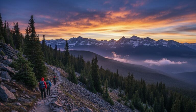
As your hiking guide, my shortcut is this: pick one “core zone” per day, then use your map to protect your time. Most first-timers should focus on Zion Canyon first, then add East Zion or Kolob as a calmer second act. When you try to cover everything in one day, you mostly cover parking lots.
Key takeaways (read this, then plan):
- Zion Canyon is the main event for classic views and beginner-friendly walks.
- East Zion (near the tunnel) is your best “big view, small effort” zone.
- Kolob Canyons is the quiet pick when Zion Canyon feels packed.
- In early March 2026, expect ice on shaded trails and possible high water closures.
- Always cross-check closures and routes on the official Zion maps page.
How I use a Zion National Park map to plan faster (and hike more)
A good Zion plan starts with the right map for the job. I like to think in layers.
First, I use an official National Park Service trail map to understand the “bones” of Zion: entrances, main roads, the tunnel, and where services sit. The National Park Service keeps the most reliable map hub on their Zion maps page, and it’s the first thing I check when seasons change.
Next, I screenshot a map I can use offline. Cell service can be spotty in the canyon, and it’s annoying to lose navigation right when you need it most. Hikers can also look into topographic maps for better elevation detail.
Finally, I plan around March realities. In early March 2026, higher and shaded routes can hold ice, slush, or snow. Also, The Narrows can close when the Virgin River runs high from snowmelt, posing a risk of flash floods. So I don’t “map dream” a route without checking conditions the day before.
Here’s the quick way I choose what to focus on:
| Map zone | Best for | What to look for on the map | My crowd-stress rating |
|---|---|---|---|
| Zion Canyon | Iconic Zion, easiest logistics | Shuttle bus stops, river corridor | High |
| East Zion | Viewpoints, short hikes | Tunnel area pullouts | Medium |
| Kolob Canyons | Quiet scenic drive and trails | Separate northwest entrance | Low |
For Zion Canyon, the Springdale shuttle is the best way to reach the visitor center without a car.
If you want a simple park-wide reference to keep on your phone, the older Zion map and guide PDF is still useful for orientation (just don’t treat it like a live conditions report).
My rule: if your map plan requires perfect parking at noon, it’s not a plan, it’s a wish.
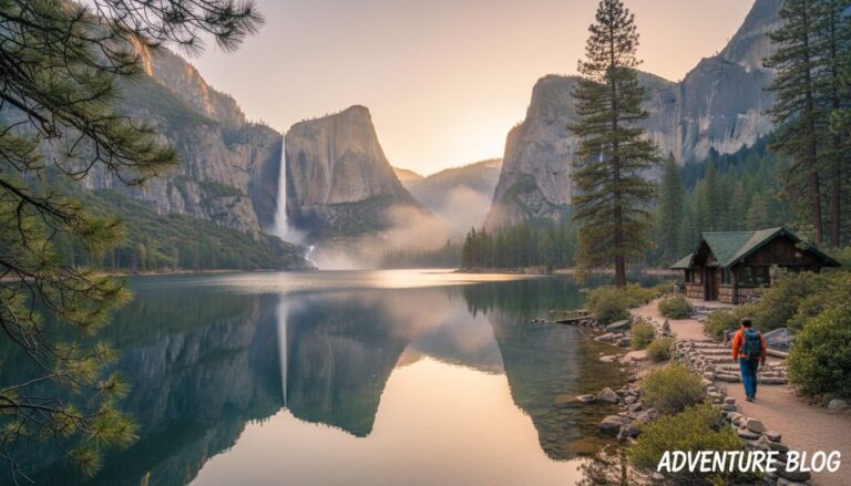
Zion Canyon: the area I’d focus on first (especially for beginners)
When people picture Zion, they’re usually picturing Zion Canyon. This is where the Virgin River runs between massive walls of Navajo sandstone, and where the park’s most famous stops cluster close together.
If you’re a beginner hiker, Zion Canyon is also the easiest place to get big scenery with low risk. You’ve got paved paths, clear signage, and plenty of “turn around anytime” options. That matters when you’re learning your pace.
A few map-based tips that save real time:
- Build your day around access rules. When the Zion Canyon shuttle bus runs, you typically can’t drive the scenic road in your own car. In 2026, the shuttle bus season starts in early March (March 7 is the key date I plan around). That one detail changes everything, including where you should park, catching the Springdale shuttle as the primary transport from town to the park entrance, and when you should arrive.
- Use the map like a menu, not a checklist. Hiking trails like Angels Landing and Emerald Pools help beginners visualize options, but I pick one anchor hike, then add a short “bonus” if I feel good. Note the Zion Lodge as a key landmark on the map.
- Start from the far end when you can. If private vehicles are allowed, I go early to the Temple of Sinawava area, then work back toward the Visitor Center.
On most first trips, I’d rather you nail a few classics than sprint between trailheads. Riverside Walk is the easiest win, Pa’rus Trail is great when you’re sore, and Watchman is a solid “earn a view” hike without scary exposure. If you want my exact beginner flow, I keep it updated here: Zion beginner itinerary with easy hikes.
Keep expectations realistic for The Narrows in March. Even if your map shows the route clearly, water level and safety closures decide whether it’s a go.
East Zion and Kolob: the best map zones when you want space
Once you’ve circled Zion Canyon on your map, I’d highlight two other areas that change the feel of your trip fast: East Zion (around the tunnel) and Kolob Canyons (a separate, quieter section of the park). The zion national park map is essential for locating remote backcountry campsites in these quieter zones.
East Zion (Canyon Overlook and the zion-mount carmel highway area)
East Zion is my favorite “short drive, huge payoff” zone. The map makes it obvious because everything lines up along the Zion-Mt. Carmel Highway. Your main planning challenge is pullouts and small parking pockets, not complicated navigation. This area offers access to the wilderness area for those seeking solitude.
Canyon Overlook is the headline here. It’s short, but it delivers a wide, classic view. Since this side sits higher, it can also hold ice in the morning, especially in shaded sections. I keep traction handy in early March.
If you like having a trail-focused map in your back pocket, the Zion nonprofit shop sells a dedicated Zion day hikes map as a supplemental hiking guide for these specific areas.
Kolob Canyons (the “why is nobody here?” option)
Kolob Canyons feels like a different park. Your map will show it as a separate finger of Zion, accessed from I-15. The scenic drive and viewpoints are great when Zion Canyon feels maxed out.
One more March note: roads at higher elevations can close after storms. Kolob Terrace Road, in particular, which leads toward Lava Point, often shuts down in winter conditions, so I treat it as a “maybe” until I confirm it’s open.
If you’re newer to hiking and want more low-stress trail ideas in general, I also keep a running list of beginner national park trails including Zion.
Conclusion: circle less, hike more
A zion national park map works best when you use it to make one strong decision: where you’ll spend your best hours. Zion Canyon first makes sense for most beginners, and focusing on Zion Canyon or Kolob Canyons ensures a high-quality experience while East Zion or Kolob helps you slow things down. Check conditions, respect closures, plan around shuttle rules, and stay alert for flash floods along with current hiking trails conditions; that is the hallmark of a prepared hiker. Do that, and your trip feels like Zion, not like traffic.
FAQs about using a Zion National Park map
What’s the best Zion National Park map to use?
I start with the official NPS Zion maps page, then save an offline screenshot of the zones I’ll visit. Physical brochure maps are also available at the entrance.
Where can I find a Zion campground map?
Check the official NPS site or visitor centers for the campground map covering Watchman Campground and South Campground.
Which area should first-timers focus on?
Zion Canyon. It has the highest concentration of iconic views, clear trailheads, and beginner-friendly walking.
Is Zion Canyon shuttle-only in March?
Usually, yes once the shuttle season begins. In 2026, I plan around the early March start (March 7), then confirm close to my visit.
Can I hike The Narrows in early March?
Sometimes, but check Virgin River flow rates since closures are common after snowmelt. Even with a perfect map, high water can shut down The Narrows for safety.
What’s the quietest part of Zion that’s still worth it?
Kolob Canyons. Your map will show it as a separate section, and it often feels far less crowded.
Do I need cell service for navigation inside the park?
No. I don’t rely on it. Download a digital trail map to your phone before you enter the Zion Canyon corridor.