Great Falls Park is one of those rare hikes near Washington, DC where the payoff arrives fast. From the Virginia entrance, you can reach roaring waterfalls and Potomac River rapids within minutes, then choose an accessible overlook stroll, a history-focused walk, or a more exposed riverside hike.
For Great Falls Park hiking, the smartest first visit is simple: arrive early, see the three overlooks first, then choose a route that matches your comfort level. The park can feel relaxed on a weekday morning and completely different on a sunny Saturday afternoon.
Key takeaways:
- The Virginia entrance opens daily at 7:00 a.m. and stays open until dark. Gates lock 30 minutes after sunset, and parking can fill early.
- A private vehicle entrance pass costs $20, and the park is cashless.
- Overlooks 2 and 3 are the most accessible viewpoints, but not every route is accessible. Expect uneven surfaces and exposure beyond the overlook area.
- Swimming and wading are illegal throughout the park, including the river and nearby streams. Pay attention to railings, drop-offs, and changing conditions near the river and overlooks.
- Check current alerts, closures, and facility updates before you go. Start with the overlooks, then build your hike around history, river views, or a longer wooded loop.
Start with the right expectations
Great Falls Park is in McLean, Virginia, about 15 miles from downtown Washington, DC. The Visitor Center helps first-time visitors orient themselves, use the restrooms, and get current information.
This isn’t a wilderness hike where you disappear for the day. Near the overlooks, expect families, photographers, runners, cyclists, dogs, and equestrians.
That said, trails farther from the overlook area get much calmer. The park has roughly 15 miles of routes, including multi-use sections for hiking, biking, and horseback riding. The Potomac River provides much of the scenery.
The overlooks are worth doing first
Don’t skip the three official overlooks because you plan to hike. The official overlooks are a short walk from the Visitor Center and parking lots, usually five to 10 minutes each, with classic wide-angle views of the falls and Mather Gorge.
Overlooks 2 and 3 are the better choices for visitors seeking accessible surfaces. Connecting paths can still be uneven, so don’t assume every route offers the same access.
The overlooks give you the postcard view, but river level and weather can change the experience. The trails show you why the Potomac River deserves more respect than it gets from a photo.
Plan around crowds, not just weather
The three lots hold more than 500 spaces combined, but they can still fill. Nice afternoons are the worst time to arrive, especially during weekend crowds. When the lots fill, the entrance road may close temporarily until spaces open up.
Nearby Riverbend Park is a separate destination, with its own entrance and parking decision. It isn’t an overflow lot for Great Falls Park. Check the official park information before leaving home for current hours, parking status, closures, and facility changes.
My advice is to get there near the 7:00 a.m. opening, especially from April through October. You’ll beat the lines, have softer light at the overlooks, and start your hike before the popular areas get noisy.
Hiking trails at Great Falls Park for a first visit
Pick the kind of hike you want before you start walking. The junctions make more sense when you have a route in mind, and it’s easy to turn a relaxed outing into a longer day by accident.
| Trail or route | Approx. distance | Best for | Terrain | Exposure | Route style |
|---|---|---|---|---|---|
| Falls overlooks | Short walks, distance varies | First-time visitors | Mostly firm paths near overlooks | Open overlooks, use barriers | Short out-and-backs |
| Patowmack Canal Trail | Approx. 1.6 miles one way | History and easy terrain | Generally wider gravel near the start | Low to moderate near river access | Out-and-back or connector |
| River Trail | Approx. 1.5 miles one way | Strong hikers and photographers | Rocky, rooted, and uneven | High, with drop-offs | Connector or out-and-back |
| Matildaville Trail | Approx. 1.1 miles one way | Canal-era history | Wooded and uneven | Low to moderate | Out-and-back or connector |
| Ridge Trail | Approx. 1.5 miles one way | Longer loops | Easy to moderate and wooded | Generally low | Connector for loops |
| Difficult Run Trail | Approx. 1.6 miles one way | A quieter extension | Creekside and uneven | Low to moderate | Out-and-back or connector |
All listed distances are approximate, and route apps may differ slightly. Rock, mud, roots, ice, and temporary closures can change trail conditions, so check current official mapping and alerts. Use the National Park Service trail descriptions first, then download an offline trail map before walking.
The best easy first hike: Patowmack Canal Trail
If you want one trail that feels like a win without feeling like work, start near the Visitor Center and follow the old canal corridor toward the holding basin, locks, canal structures, and river views.
The canal-side section is generally wider and easier near the start. Farther along, surfaces can vary, so verify current surfaces, closures, and accessible facilities before setting out.
You can walk out for 30 to 45 minutes, turn around whenever the group is ready, and still get a full Great Falls experience.
This is also the best trail for anyone who likes a hike with a story attached. George Washington backed the canal project in the late 1700s to help boats bypass the falls. The project didn’t turn the Potomac into the commercial route he hoped for, but its canal-era history still adds context to the park.
The best scenic challenge: River Trail
River Trail follows Mather Gorge and connects the canal corridor with the ridge route. It brings you closer to the Potomac River’s force than any overlook can, with dramatic scenic views.
River Trail is also where Mather Gorge makes the exposure feel real to first-timers. Expect roots, uneven rock, narrow passages, steep drop-offs, and spots where you need to watch every step. Occasional light rock scrambling is possible, but this isn’t a technical climb.
If heights make you tense, skip it. You will still get excellent scenery on the canal route and overlooks, so turn around if the exposure feels too much. If you do take it, wear shoes with grip, keep kids close, and don’t drift toward the cliff edge for a better photo.
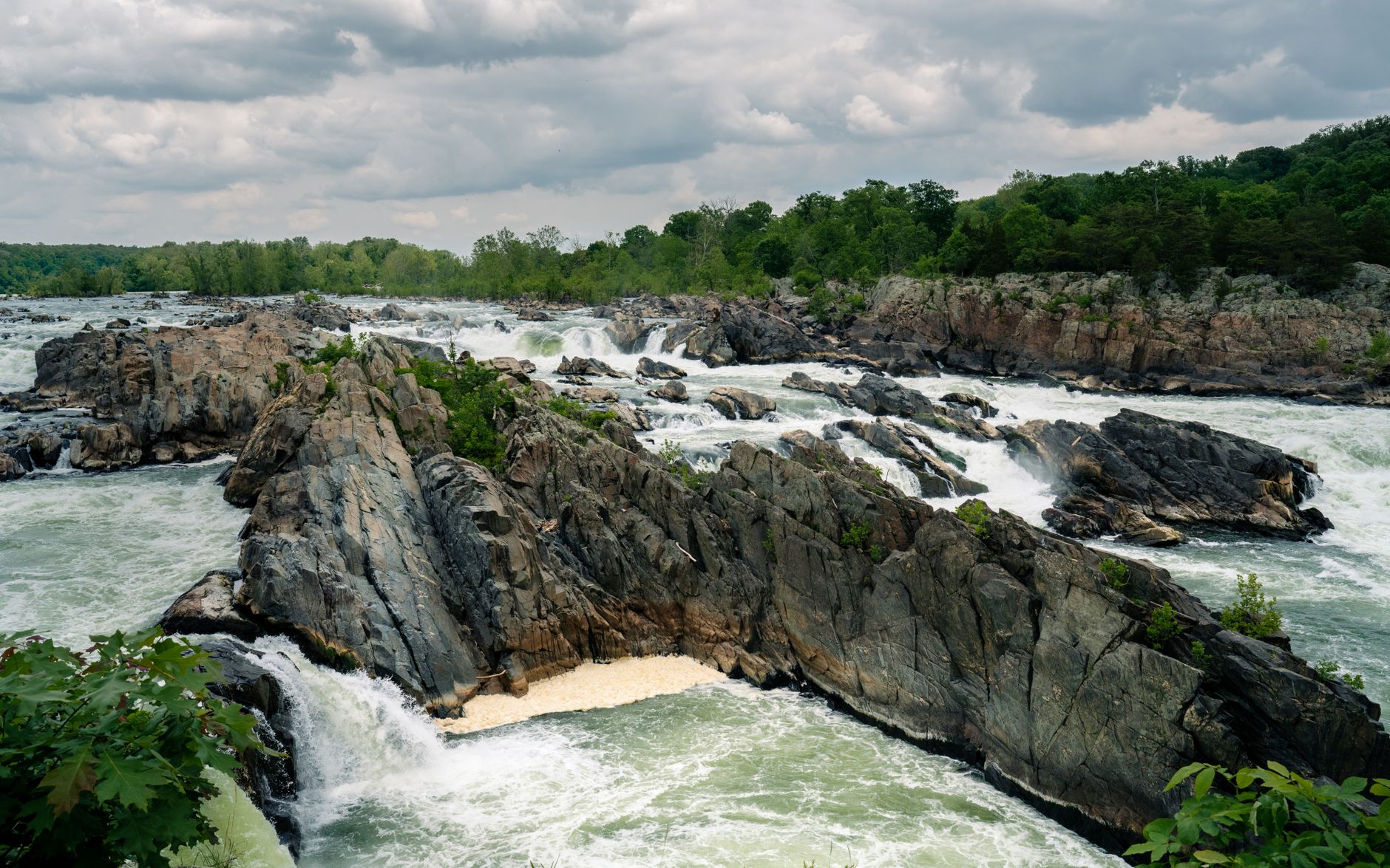
Photo by Wilson Rodriguez
A simple first-time Great Falls Park itinerary
For most beginners, two to three hours works well for the overlooks and one flexible route. A longer loop takes more time, depending on your pace, photo stops, crowding, and current conditions.
Start near the Visitor Center to use the restrooms, fill water bottles, and get oriented, then walk to all three overlooks before choosing a longer route. Crowds usually build as the morning goes on.
The 2-mile history and views plan
After the overlooks, follow the Patowmack Canal Trail toward the holding basin and canal ruins. The Mather Gorge viewpoint provides the main payoff, either before or after this walk. Turn around whenever you like; the nominal two miles isn’t mandatory.
This is best for families, casual hikers, anyone visiting in hot weather, or groups with mixed fitness levels. The scenery comes quickly, and you can make the walk as short or long as you want.
Bring a snack and claim a picnic table afterward if one is open. Picnic tables and grills are first come, first served, so don’t build your day around getting one. Tables, restrooms, and overlook approaches may have different surfaces, so verify current accessibility information before you go.
The longer loop for active beginners
If everyone in your group wants more miles, link the canal route with River Trail, Ridge Trail, Old Carriage Road, and Swamp Trail. Expect roughly four to five miles, but don’t treat that as a fixed guarantee. Junction choices, temporary closures, your pace, and comfort with exposure can change the route.
Start with the canal, then add the riverside section only if everyone feels comfortable. Skip it if anyone is uneasy with heights or if the rock is wet or icy, then use wider inland routes for the return.
Keep an eye on your map at every junction. The park is compact, but a casual “let’s see where this goes” approach can add miles fast.
Add history on the Matildaville Trail
Great Falls offers more than dramatic waterfalls. Matildaville Trail adds a quieter layer to the day, passing remains of a canal-era settlement once tied to the Patowmack Canal.
The historic ruins are subtle, with uneven foundations and scattered stonework. Don’t expect a fully restored historic village with big signs at every turn. It is a walk-through-the-woods history lesson, with lightly signed woodland paths leading to traces of the community that existed here more than two centuries ago.
Pair Matildaville with Old Carriage Road
The route connects to Ridge Trail and works well in a larger loop. The less-exposed inland route gives hikers more distance without cliffside walking. Check the current park map and alerts before setting out, since paths and access can change.
The road is wider and multi-use. Watch for cyclists and equestrians, yield to them, and keep dogs close. It is not the most dramatic trail in the park, but it is useful when you want a more forgiving route back.
If you are extending a Virginia road trip beyond Great Falls, these best hikes in Virginia include bigger waterfall days and ridge hikes worth saving for later.
Difficult Run Trail is better as an add-on
Difficult Run Trail follows the stream corridor between Georgetown Pike and the river. It may be less crowded than the main falls area, with rocky cascades, woods, and a tucked-away feel.
The trail is a connector, not a signed loop. You can hike it as an out-and-back, or pair it with Ridge Trail, River Trail, and Swamp Trail for a longer circuit.
Do not trust one mileage number
This is where trail research gets messy. The current park hiking page lists Difficult Run at 1.6 miles one way, while an older park planning document gives a much shorter measurement. Those figures may refer to different segments or access points.
The access point near Georgetown Pike can affect how you interpret the mileage and plan your return. For a first trip, don’t obsess over the exact number. Treat it as a flexible add-on, and carry the current trail map recommended earlier.
Use current official trail descriptions and alerts before route-app estimates, and conserve energy for the return. Turn around before trail conditions exceed your comfort level, especially if a Swamp Trail extension adds distance. Creekside rocks, mud, leaves, and water levels can change after rain, while slippery rocks, dogs, and weather may require extra care.
Fees, pets, safety, and what not to do
The entrance fee for a private vehicle is $20 and remains valid for seven consecutive days. Visitors often search for a parking fee, but this is officially a vehicle entrance fee. An annual pass costs $35, and America the Beautiful passes are accepted. The park is cashless, so bring a card or buy a pass online before you arrive.
Dogs are welcome on some trails, but they must stay on a six-foot leash and under physical control. There are no off-leash areas, and pets can’t enter the Visitor Center unless they’re service animals. Ask staff about current pet access, service-animal rules, water, and restrooms.
The river is not a swimming hole
The water can look inviting on a warm day, especially near the rocks. Swimming and wading are prohibited in both the Potomac River and the creek corridor along Difficult Run Trail.
Hydraulics, submerged rocks, changing water levels, and falls can turn dangerous fast. On River Trail, narrow sections, drop-offs, and wet rock can make approaching the edge for photos especially dangerous. Stay behind railings, never climb railings or fences, and keep children within arm’s reach near overlooks and river edges. Review the park’s official falls viewing safety rules and current alerts before your visit for the latest safety warnings.
Pack for the terrain you will actually walk
You don’t need a full backcountry kit here. Still, wet woodland paths and rocky sections aren’t a good place for smooth-soled casual shoes.
Bring:
- Trail runners or hiking shoes with grippy soles, especially if rain is in the forecast.
- Water, snacks, sunscreen, and a light rain layer.
- A charged phone with your route downloaded for offline use.
- A six-foot leash, water bowl, and extra water if your dog is joining.
Skip sandals on rocky paths. Cell service may be inconsistent, so don’t count on it for navigation.
When to visit Great Falls Park
Spring is arguably the prettiest time to hike here. The river runs high, the woods turn green, and early wildflowers add color. Check current official trail conditions, alerts, and closures before leaving home.
Summer brings lush foliage, humidity, heat, and afternoon thunderstorms. Start at opening, carry more water than you think you need, and shorten your hike if storms approach. Recent rain can leave rocks, roots, creek edges, and overlook approaches slick.
Fall is my favorite season for this park. Cooler temperatures and colorful foliage make longer loops more comfortable, and the light is hard to beat. Weekends still get busy, so don’t assume the park will be quiet.
Winter can be peaceful, but ice, freezing rain, and reduced daylight change the equation. Wear footwear with solid traction, choose a conservative route after snow or freeze-thaw cycles, and turn around when surfaces become unsafe.
Final Thoughts on Your First Visit
The best route fits your group’s ability, comfort with exposure, and available time, not the toughest option on the map. Start with accessible overlooks, add canal history if you have time, and choose the more demanding riverside option only when rocky footing feels comfortable.
Arrive early, check current information, and stay behind barriers while respecting the river and overlooks. Leave enough time for a conservative return route, with a moment to enjoy the waterfalls.
Frequently Asked Questions
Is Great Falls Park good for beginner hikers?
Yes, especially if you stick to the overlooks and the canal route. Both offer impressive scenery without forcing you onto narrow, rocky terrain.
River Trail is better for confident hikers with shoes that grip well. Its rocky footing and exposed sections can feel challenging for nervous beginners.
Where is Billy Goat Trail compared with Great Falls Park?
Billy Goat Trail is on the Maryland side of the Potomac River, within the C&O Canal National Historical Park. It isn’t part of Great Falls Park in Virginia.
The two areas are close geographically, but they have separate entrances, parking, trails, and rules. Don’t assume you can quickly drive between them after parking.
Can you swim or wade at Great Falls Park?
No. Swimming and wading are prohibited throughout Great Falls Park, including in the Potomac River and around Difficult Run Trail.
The rapids and currents are dangerous even when the water looks calm near shore. Keep the water as scenery, not part of the hike.
How long should I plan for Great Falls Park?
Plan two to three hours for parking, restrooms, the Visitor Center, the overlooks, and one trail. That allows for a relaxed first visit.
A four- to five-mile loop using multiple trails can take three to four hours with photo stops and breaks. Allow more time for crowds, route changes, and current conditions.
Before visiting, verify current hours, entrance fees, parking details, and accessibility with official NPS sources.