You can stand beneath a wall of dinosaur fossils in the morning, hike through silent desert country after lunch, and watch the Green and Yampa rivers cut through a canyon by evening. The catch is that Dinosaur National Monument is huge, split between Utah and Colorado, and easy to underestimate.
The smart way to plan hikes in Dinosaur National Monument is to pick one side per day. The Utah side has fossils, petroglyphs, and close-up slickrock trails. The Colorado side is for big canyon overlooks and a quieter, more remote feel.
Key Takeaways
- Start on the Utah side if you want the Quarry Exhibit Hall, rock art, and the best short hikes near Cub Creek Road.
- Choose the canyon area for Harpers Corner Trail and massive views over the Green River and Yampa River canyons.
- Hog Canyon Trail is the easier option, while the Sound of Silence hike is a more demanding desert route with steep slickrock, scrambling, and little shade.
- Bring more water than you think you’ll need. Summer temperatures can climb above 100°F, and many trails offer zero relief from the sun.
- Don’t bring a dog expecting full trail access. Pets are prohibited on most hiking trails.
Dinosaur National Monument hiking: Utah side or Colorado side?
The monument’s two main areas feel like separate parks. You can visit both on the same trip, but trying to do both in one rushed day means more driving than hiking.
Choose Utah for fossils, rock art, and desert trails
The Utah side near Jensen is the better first stop for most visitors. Start at Quarry Visitor Center, where the Quarry Exhibit Hall puts you face-to-face with fossils still embedded in the Morrison Formation rock wall.
From there, Cub Creek Road leads toward short hikes, the Josie Morris Cabin area, petroglyphs, and the desert loop. This is the side I’d choose if you’re short on time or hiking with beginners who still want a real desert experience.
The last stretch of Cub Creek Road is unpaved, and conditions can change after storms. Build in a backup plan rather than treating one trail as non-negotiable.
Choose Colorado for canyon-scale views
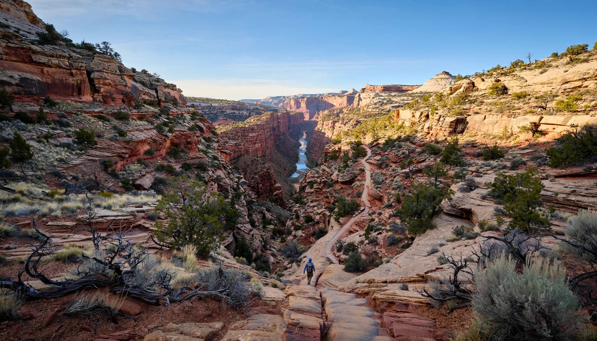
The Colorado side begins around the Canyon Visitor Center near Dinosaur, Colorado. Its centerpiece is the 31-mile Harpers Corner Road, a paved scenic drive with overlooks and access to the Harpers Corner Trail.
This area feels bigger, quieter, and more remote. You’re not coming here for fossil exhibits. You’re coming for rim views over Whirlpool Canyon, Steamboat Rock, Split Mountain, and the meeting point of the Green River and Yampa River.
Best trails for your first visit
The official Dinosaur National Monument hiking trail list is the right place to confirm active closures before you leave. Trails here can be affected by washouts, debris, rockfall, and muddy roads after weather moves through.
| Trail | Distance | Elevation gain | Best For |
|---|---|---|---|
| Sound of Silence | 3.2 miles round trip | About 400 feet | Slickrock and desert geology |
| Hog Canyon | 1.5 miles round trip | About 100 feet | An easier box canyon walk |
| Harpers Corner | 2 miles round trip | About 100 feet | Huge river canyon views |
For a first trip, I’d pick one substantial hike and leave room for scenic stops.
Sound of Silence trail is the Utah-side favorite
The Sound of Silence route is a 3.2-mile loop with roughly 400 feet of elevation change. It’s rated moderate to difficult, and that feels fair. The route crosses a wash, climbs steep slick rock, and includes some scrambling.
The payoff is classic Dinosaur country: tilted rock layers, desert badlands, wide-open views, and the odd feeling that you’re walking through a place almost nobody knows exists.
Don’t take the rating lightly, though. NPS has reported washouts, debris, and missing signs here after storm damage. Wear shoes with real grip, download an offline map, and don’t continue with off-trail hiking if markers disappear. This isn’t the hike for casual sandals.
Hog Canyon Trail and Harpers Corner are better beginner picks
Hog Canyon Trail starts near the Josie Morris Cabin parking area. It is a 1.5-mile out-and-back hike with around 100 feet of elevation gain, leading into a fairly level box canyon. You’ll see exposed Weber Sandstone along the way.
Harpers Corner is the Colorado-side must-do. The Harpers Corner Trail is two miles round trip with about 100 feet of elevation gain. NPS describes it as easy to moderate in one trail listing and moderate on its dedicated page. I’d plan for moderate, especially with wind, heat, or younger hikers.
The Harpers Corner Trail follows a narrow ridge to a massive viewpoint. If you’re comfortable with open drop-offs nearby, this is one of the monument’s biggest rewards for the effort.
Jones Hole, Box Canyon, and longer river days
Jones Hole Trail follows a lush creek corridor that feels completely different from the dry Utah-side routes. Access is near the Jones Hole Fish Hatchery, 47 paved-road miles north of Quarry Visitor Center. Check the Jones Hole Trail access details before committing, since a short detour near the trailhead has been in place.
I wouldn’t label Jones Hole as a casual first backpacking trip without talking with a ranger first. Route length depends on your turnaround point or shuttle plan, and current access conditions matter. Any shuttle or overnight logistics make this a planned creek-canyon outing, not an ordinary casual day hike.
Box Canyon Trail and Lizard Petroglyph Trail are good options to keep in your back pocket. Check their status at the visitor center, then use them as flexible additions rather than building your whole day around them.
Find petroglyphs, fossils, and the monument’s rock layers
Dinosaur National Monument has 24 exposed rock layers. You don’t need a geology degree to enjoy them. The fun is seeing how the trail changes beneath your feet, from pale slickrock to dark canyon walls and crumbly badlands.
Start with the Quarry Area and Morrison Formation
The Quarry Area is where the monument earns its name. Its fossil wall displays prehistoric fossils within the Morrison Formation, a layer famous across the American West.
The Fossil Discovery Trail is officially 1.2 miles one way, but the spur toward the fossil wall has been closed because of rockfall risk. The usable corridor between Quarry Visitor Center and Quarry Exhibit Hall is still a worthwhile walk, especially if you want to stretch your legs before a longer hike.
For another Utah desert hiking day, this Arches National Park one-day hiking itinerary has the same no-shade reality: bring water, sun protection, grippy shoes, and a headlamp if the day runs long.
Treat petroglyphs like the irreplaceable resources they are
The Lizard Petroglyph Trail and Swelter Shelter area offer a chance to see rock art without a long wilderness hike. Rock art was carved into rock, while pictographs were painted onto it. Both deserve distance and respect.
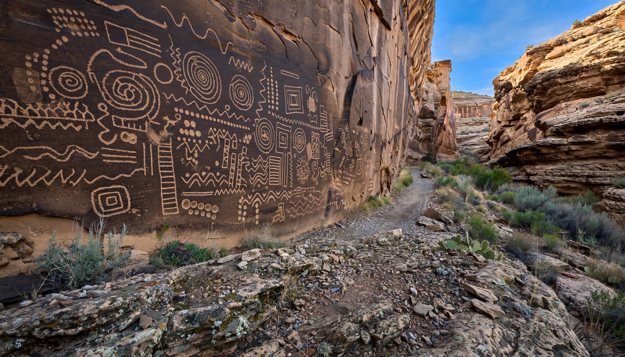
Don’t touch the rock, trace markings, wet surfaces for photos, or alter the site by adding your name nearby. A close photo with a zoom lens is better than one step too close.
Rock art is not trail decoration. It is a cultural record that has already lasted far longer than any of us will.
A simple one-day plan that doesn’t feel rushed
The best Dinosaur National Monument days have a clear focus. You can stack a few stops, but don’t turn every overlook into a race.
Spend your Utah day around Quarry and Cub Creek
Begin at Quarry Visitor Center when it opens. Visit the Quarry Exhibit Hall first, then walk the accessible Fossil Discovery Trail corridor if conditions allow.
After that, drive Cub Creek Road and choose one main hike. Sound of Silence is my pick if everyone is steady on uneven terrain. Hog Canyon Trail is the safer bet for a lower-key afternoon.
Leave time for petroglyph stops and Josie Morris Cabin. Pack lunch, because services are limited once you leave the developed area.
Make the Colorado side a scenic-drive day
Start at Canyon Visitor Center, then drive Harpers Corner Road without pressure to stop at every pullout. Echo Park is another option, but check current road conditions before committing to the remote drive.
Save your longest stop for Harpers Corner Trail, preferably later in the day when the canyon walls have more depth and contrast.
Winter is the big caveat here. Snow and ice can make Harpers Corner Road impassable, so don’t assume the drive is open based on the calendar.
If you enjoy scenic drives with short, high-reward walks, a Canyonlands scenic drive and hiking guide is another good model for planning a low-stress Utah road-trip day.
Desert hiking safety that matters here
This monument doesn’t need extreme mileage to feel serious. Heat, exposed rock, sudden weather, and long drives can turn a simple hike into a rough afternoon fast.
Beat the heat before it beats you
Start early, especially from late spring through early fall. Carry a full water supply before leaving the trailhead, plus salty snacks and adequate sun protection.
Sunglasses and a brimmed hat help, too. I also bring a light layer because desert mornings can be cool and wind can pick up on the Colorado rims.
Thunderstorms can move in faster than you’d expect. If you’re fading before the turnaround point, turn back.
There is no prize for finishing a loop when you’re overheated and out of water.
Watch your footing, weather, wildlife, pets, and route choices
Slickrock gets slippery when wet, washes can flash flood, and muddy roads can become impassable. Check the weather, give wildlife plenty of space, tell someone your plan, and keep an offline map on your phone.
Don’t treat off-trail hiking as a casual shortcut. Ask a ranger about the area you have in mind, stay away from cultural sites, and don’t enter terrain you can’t confidently retrace.
Pets must stay on a leash no longer than six feet. They are prohibited on most hiking trails, visitor centers, the shuttle, and Quarry Exhibit Hall. The monument’s regulations list limited exceptions, including River Trail and the designated trail at Swelter Shelter. Check current regulations before you go.
A final thought before you go
The best hike here isn’t always the longest one. It’s the trail that fits your group, the weather, and the side of the monument you’re already exploring.
Pick one main objective, start early, and keep a backup route ready. Dinosaur National Monument rewards flexibility far more than a packed itinerary.
Frequently Asked Questions
What is the best hike for first-time visitors?
Sound of Silence is the best overall Utah-side hike if you’re comfortable with slickrock and a moderate challenge. For an easier option, choose Hog Canyon Trail. On the Colorado side, Harpers Corner gives you the biggest canyon payoff in only two miles.
Are dogs allowed on trails in Dinosaur National Monument?
Usually, no. Dogs aren’t allowed on most hiking trails. Leashed pets are permitted on River Trail, Swelter Shelter Petroglyphs trail, and a few designated Colorado-side routes. Confirm the current rules before your visit.
Is Sound of Silence suitable for beginners?
Fit beginners can manage the route if they start early, bring enough water, and wear shoes with solid traction. It includes steep slickrock and some scrambling, so skip it if anyone feels uneasy on uneven terrain.
Is Jones Hole Trail good for a beginner backpacking trip?
Jones Hole Trail is better approached as a planned creek-canyon outing than an impulsive first overnight. Access logistics, trail conditions, and your turnaround point all matter. Check with the visitor center before using it for a backpacking plan.