Mount St. Helens can offer a huge volcanic view after a short walk, or make you earn it over miles of loose pumice. This hiking guide compares Mount St. Helens hiking trails, and for most first-time visitors, Hummocks Trail is the smart starting point.
The Mount St. Helens National Volcanic Monument has trailheads on several sides, and they don’t connect by a quick drive. Pick your view first, then check whether you can reach the trailhead.
Key Takeaways
- Choose Hummocks Trail for an approachable first look at the 1980 blast zone.
- Head toward Norway Pass for a bigger Spirit Lake view, but confirm east-side road and trail access first.
- Save Monitor Ridge for a strenuous summit day with the required climbing permit.
- Check SR 504, Forest Roads 25 and 99, and the exact trailhead before leaving. A road closure can change your whole plan.
Mount St. Helens hiking trails ranked by payoff
This ranking balances scenery, effort, and the kind of experience each route offers. Distances and elevation gain are approximate, and access can change with road closures, weather, and trail conditions, so check current Forest Service information before you go.
| Rank | Trail | Views and route details | Difficulty and best fit |
|---|---|---|---|
| 1 | Hummocks Trail | About 2.4 miles round trip with little elevation gain. Rolling blast-zone hills, ponds, and mountain views. | Easy. A rewarding first hike for beginners and families; expect uneven footing and limited shade. |
| 2 | Norway Pass | About 2.2 miles round trip, with roughly 600 feet of elevation gain. The pass looks toward Spirit Lake and volcanic terrain. The Boundary Trail continues from the pass, but route conditions and access can vary. | Moderate. A strong viewpoint hike for hikers comfortable with a steady climb and exposed sections. |
| 3 | South Coldwater Trail | Roughly 8 miles round trip, with about 1,400 feet of elevation gain. Forest, lake, and mountain views make this a west-side alternative. | Moderate. Suits hikers wanting a longer forest outing; expect some sustained climbing. |
| 4 | Meta Lake | About 0.7 miles round trip with minimal elevation gain. Short boardwalk sections and viewpoints show how plants are returning to the landscape. | Easy. A quiet, short east-side stop for visitors interested in blast zone recovery. |
| 5 | June Lake | About 2 miles round trip, with roughly 500 feet of elevation gain. The route reaches a waterfall and lake in a forested south-side setting. | Easy to moderate. Good for hikers seeking shade and water; the trail can be rocky and slippery near the falls. |
| 6 | Plains of Abraham | Around 12 miles round trip, with roughly 1,500 feet of elevation gain via Ape Canyon. Open pumice and stark mountain views define the route. | Hard. Best for experienced hikers ready for a long, exposed day with loose volcanic footing. |
| 7 | Monitor Ridge | About 10 miles round trip, with roughly 4,500 feet of elevation gain. The route climbs to the summit and crater rim. A climbing permit is required, and conditions can make the ascent more demanding. | Very hard. For fit, experienced climbers prepared for steep, exposed terrain and changing weather. |
| 8 | Loowit Trail | Roughly 30 miles around the mountain, with substantial cumulative climbing. Views shift across forests, lava, and the blast zone. | Extreme. A multi-day route for experienced backpackers; check current closures and plan carefully for water and exposed terrain. |
Windy Ridge offers an east-side viewpoint and a way to see the Pumice Plains, but it isn’t the Norway Pass hike. Start with access, not rank. Norway Pass might be your ideal hike on paper, but Hummocks is the better choice if east-side roads or trails are closed. If you’re planning a longer Washington trip, my best hikes in Washington guide has options when the volcano’s weather doesn’t cooperate.
Best easy hikes for a first visit
Hummocks Trail: the best view-to-effort trade
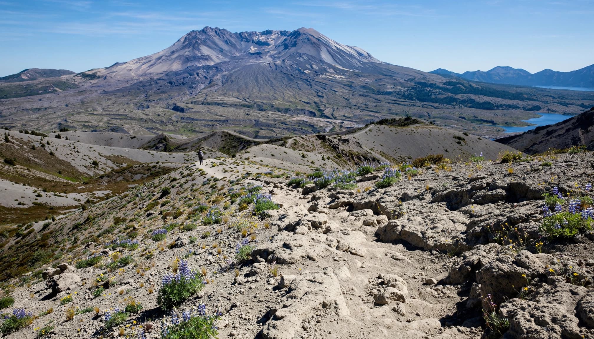
If you have one short hiking window, I’d start here. Hummocks are enormous chunks of mountain deposited during the 1980 eruption. Walking among them gives you a feel for the scale of the blast zone without committing to an exposed climb.
The full loop is about 2.4 miles with roughly 100 feet of elevation gain. A viewpoint about one mile round trip from the trailhead makes a manageable goal. Watch for uneven ground, and bring water even on a cool day.
The west-side drive also pairs well with Coldwater Lake. This is an ordinary hike, not a summit route above the 4,800-foot permit threshold, so you don’t need a climbing permit.
Meta Lake and June Lake: two different easy days
Meta Lake is my pick when you want to see how plants and forest have returned inside the blast zone. The short trail is about 0.5 mile round trip with around 100 feet of elevation gain. It’s on the east side, so check road access before treating it as a quick stop. The path can be uneven, and late spring or early summer may bring wildflowers.
June Lake, reached from the south-side trail system, is about 1.6 miles round trip with roughly 400 feet of elevation gain. It trades open ash slopes for forest, water, and a waterfall, with roots and muddy patches possible underfoot. It’s a good choice when the upper mountain is windy or hidden by clouds, but it’s a separate outing, not a summit approach.
For another south-side outing, check current access and trail conditions for Lava Canyon before planning a visit. Its gorge and waterfalls make it a distinct stop, not an extension of June Lake. Ape Cave is also nearby, so save it for a separate visit rather than squeezing it into an already full hiking day.
Moderate hikes with bigger volcanic views
South Coldwater Trail: a west-side climb worth checking
South Coldwater is a good step up after Hummocks. Plan on about 5 miles round trip and roughly 1,000 feet of elevation gain. Views toward the mountain begin about 1.5 miles uphill, so you can turn around there instead of continuing. Expect a sustained climb, sun exposure, and uneven footing.
For 2026, the South Coldwater Trailhead is walk-in only, according to the Mount St. Helens Institute’s visitor access guidance. Allow extra time for the approach, especially if you’re aiming for the viewpoint.
Norway Pass: the Spirit Lake favorite
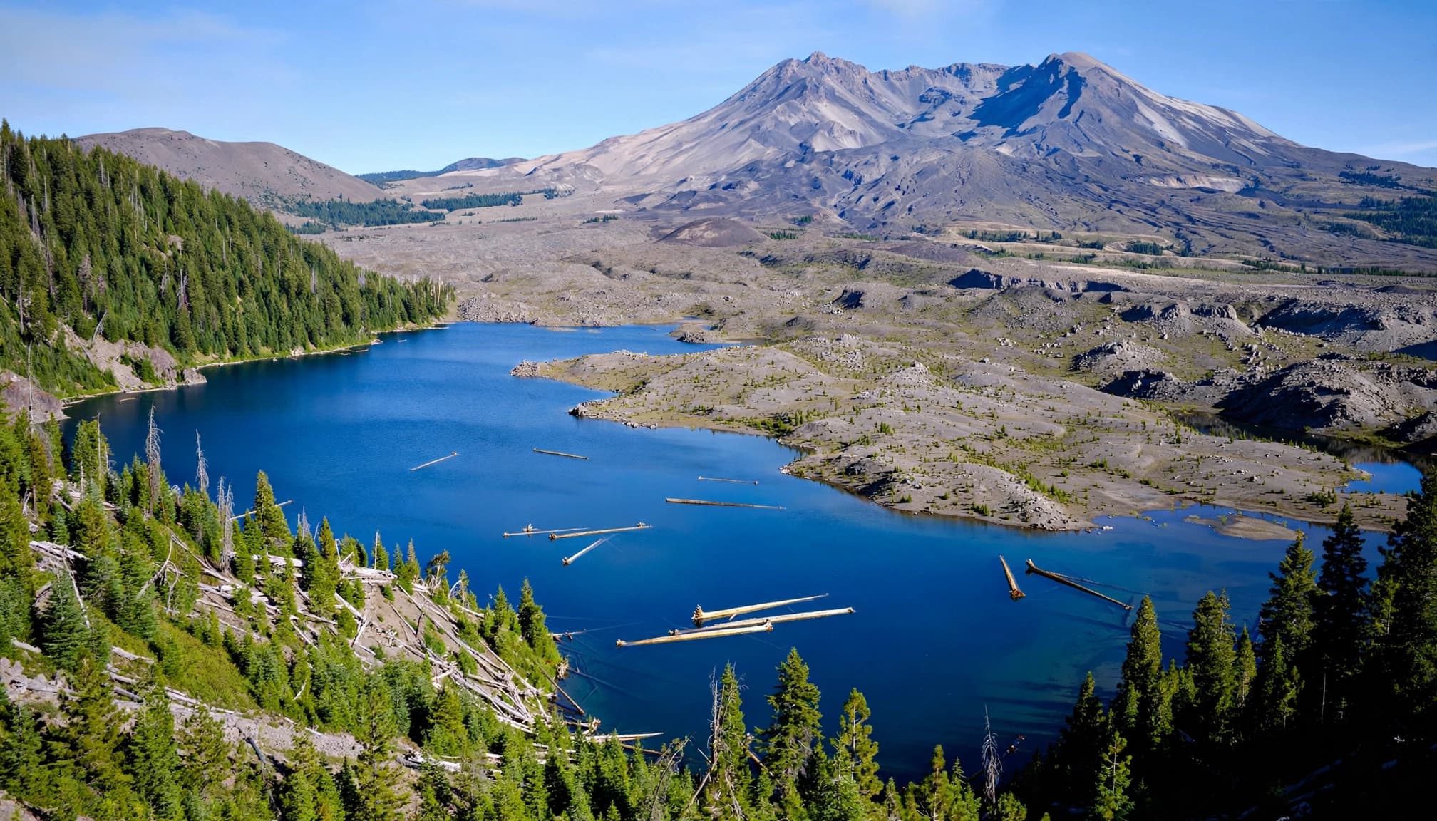
Norway Pass offers views of Spirit Lake, Mount St. Helens, and the surrounding blast zone without a summit permit. The route is about 3.5 miles round trip with roughly 900 feet of elevation gain. It’s a distinct destination from the Pumice Plains, not a route to them.
This moderate hike suits hikers comfortable with exposed slopes and variable footing. Wind, sun, and lingering snow can change conditions quickly, and floating logs on the lake may be visible but aren’t guaranteed. Check current east-side access and trail conditions before driving out, and allow more time than you would for a sheltered forest trail.
Hard hikes for the full blast-zone experience
Plains of Abraham: big scenery, little shelter
Want to feel surrounded by the volcano rather than admire it from a viewpoint? The Plains of Abraham crosses broad, exposed pumice slopes, with views across the blast zone and toward the crater. The route is roughly 8 miles round trip with about 1,500 feet of elevation gain, best suited to strong day hikers comfortable with route-finding and little shade.
Plan your route and turnaround before setting off. Pumice Plains is a separate named area, not another name for Plains of Abraham, so check that maps and access notices refer to the right destination. Blowing grit can slow progress, and Norway Pass is a more forgiving introduction to volcanic terrain.
Loowit Trail: a serious trip around the mountain
The Loowit Trail circles Mount St. Helens in roughly 32 miles, with about 5,700 feet of cumulative elevation gain. Its changing views take in forest, lava, gullies, and open volcanic slopes, with rough stretches that include boulder fields.
This is a backpacking commitment, not a casual long day hike. Water can be scarce, crossings can be difficult, and camping restrictions and closures may affect your itinerary. Don’t assume access information for Pumice Plains applies to this circuit; check current alerts and route details before leaving. The Washington Trails Association’s Loowit Trail information is a useful starting point for route details and recent reports.
On the Loowit, mileage alone understates the effort. Loose footing and repeated gullies can make a short stretch take much longer than expected.
Climbing the summit: routes and permits
Monitor Ridge versus Worm Flows
Monitor Ridge is the usual snow-free-season summit route from the south, starting at Climbers Bivouac. Expect about a ten-mile round trip and 4,500 feet of elevation gain, much of it over rocky or loose volcanic ground. The crater rim view is a major reward, but this isn’t where I’d send a beginner for their first volcano hike.
Worm Flows is the common winter and spring climbing route. Snow and ice make it a different undertaking, even if you’re comfortable on summer trails. Check current conditions and carry the skills and equipment the day requires.
Stay back from the crater edge. Cornices can extend beyond solid ground when snow is present.
When do you need a climbing permit?
The Forest Service’s Mount St. Helens summit rules require authorization for each person traveling above 4,800 feet. This applies to summit attempts, not ordinary hikes such as Hummocks or Norway Pass.
From April 1 through October 31, reserve through Recreation.gov. Seasonal dates, release schedules, daily limits, and fees can change, so check current rules before planning. Winter permits are free and self-issued.
Road closures and the route to your trailhead
West side: State Route 504 access to Johnston Ridge Observatory
A landslide-related closure has affected State Route 504 between mileposts 45.2 and 51, limiting vehicle access to Johnston Ridge Observatory. Check current transportation and Forest Service notices before planning a drive to the observatory or nearby viewpoints, since conditions can change.
You can still plan a west-side outing around Hummocks and Coldwater Lake. Check current parking and trail instructions, especially for South Coldwater’s walk-in access. There isn’t a simple west-side driving detour to Johnston Ridge Observatory, and a trail closure may affect nearby routes.
East side: approach Windy Ridge through Randle
The usual east-side approach to Windy Ridge runs through Randle, then follows SR 131 and Forest Road 25 to Forest Road 99. From the junction, FR 99 continues toward Windy Ridge. Check current road notices before driving, as conditions can change.
Some east-side routes near Spirit Lake have had construction restrictions. Check current notices for your specific route and hiking date, including the Boundary Trail and access to Pumice Plains. Where current maps and notices show the route open, confirm how it connects to Pumice Plains before setting out. An open road doesn’t mean every trail is open.
The simplest pre-trip plan is to save an offline map, check road and trail alerts the night before, then check again before the drive. Check parking-area rules, including whether a Northwest Forest Pass is required. Keep Hummocks or a south-side Mount St. Helens hike as a backup if your east-side route falls through.
What to pack for pumice, wind, and a cave visit
Protect your feet and carry your own water
Volcanic grit gets into shoes and wears on exposed skin. Wear sturdy footwear, consider gaiters for loose pumice, and bring trekking poles if steep descents bother your knees. Lava Canyon has rocky footing, so sturdy shoes matter there too. An N95 mask is a sensible addition when ash or dust is blowing.
Carry ample water rather than counting on a refill along an exposed route. Add sun protection, a warm layer, a wind or rain shell, and an offline map. The same slope that feels pleasant at the trailhead can be cold and abrasive higher up.
Treat Ape Cave as its own adventure
Ape Cave is a lava tube, so families get a close look at a very different part of the volcano’s history. It’s also dark, uneven, and about 42°F inside. Bring warm clothing and two reliable light sources per person; a phone flashlight isn’t enough.
Seasonal timed-entry reservations apply. Check the current schedule and access details before driving to the Ape Caves visitor area. It’s a memorable stop, as long as everyone in your group is comfortable with cold, dark spaces.
Frequently Asked Questions
Where can I see Spirit Lake without climbing the summit?
Norway Pass is my hiking pick when access and conditions line up. Windy Ridge is another east-side area to check for lake views. Neither requires summit authorization, but road and trail restrictions may affect your visit.
Can I hike to Johnston Ridge Observatory in 2026?
Don’t plan on the usual SR 504 vehicle approach. Check current road conditions before you go, as the upper road has been closed after the landslide. The site may remain inaccessible by vehicle, so consider an open west-side trailhead instead.
Which south-side hike is best for beginners?
June Lake is a better beginner hike than a summit route when you want a manageable forest outing. Ape Cave is another option, though its cold, dark, uneven passage calls for its own preparation.
Do I need a Northwest Forest Pass as well as a climbing permit?
A parking pass and authorization to climb are separate requirements. Check the listing and posted rules for your exact parking area to see which pass, if any, is needed.
Pick the view you want, then check the road
For a first visit, I’d choose Hummocks for easy blast-zone scenery or Norway Pass for a bigger Spirit Lake day when access is clear. For an east-side option, consider Pumice Plains when route access is open. Save the summit and Loowit Trail for trips you can prepare for properly.
The mountain rewards a little flexibility. Verify route access before you leave, keep a backup hike handy, and you’ll spend more of your day on the trail.